Forum: Announcements
Forums / Announcements / Update - 14 July 2010 - v0.7.5
| Subject: | Update - 14 July 2010 - v0.7.5 | |
Stephen 21:37 Location: Phone Model: | v0.7.5 Released As it seems that for one reason or another I keep being delayed with finalising this release, I've decided to just go ahead and release it, and shall probably follow this up fairly soon with a further version with a couple of other additions. So, for now... - Addition of auto-routing by Cyclestreets in the list of routing Methods, providing Cycling-specific routing in the UK. (Thanks to Martin and Simon for their assistance and permission to use their routing API) - Vector Maps now include the ability to highlight any OpenStreetMap 'Route' Relations in the area, for example to show local Bus Routes, Cycle Routes, Walking Routes, etc. 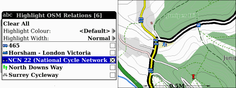 (Full size) - The Plan page Vector Maps can now display altitude Contour lines, derived from OS 1:50,000 Panorama (UK only) or SRTM data (rest of world). 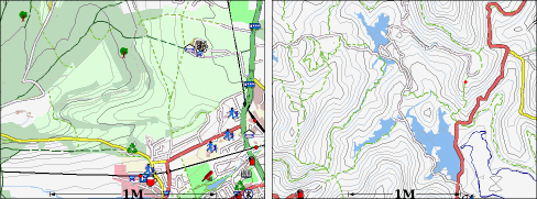 (Full size) - Vector Maps now include embedded height/altitude information derived from NASA SRTM data, displayed on the Measurement Ruler, the 'View Coordinates' menu function and also used when adding new waypoints/routepoints on the Plan page to include an estimated altitude in the stored point. And also... - Re-written the Online Raster code to improve responsiveness. - Improved/clearer drawing of dotted/dashed lines (ie Footpaths and Bridleways) on the Plan view Vector Maps. - Internal GPS version shows Horizontal and Vertical Accuracy in place of the Satellites and HDOP/VDOP values. - Plus other small updates and bug fixes... Cheers, Stephen | |
(You must be logged in to post a reply to this thread)